Show the globe from space. What does the earth look like from different points in the solar system?
Remember the movie “Men in Black”, where Agent Kay looked through an orbital camera at his beloved watering flowers in the courtyard? The opportunity to see what our Earth looks like from a satellite in real time attracts people from all over the world. Today we will tell you - and show you! - the best fruits modern technologies on Earth observation.
Attention! If you see a dark screen, it means the cameras are in the shadows. Screensaver or gray screen - no signal.
Usually we only get static satellite maps, frozen in time - the details are not updated for years, and an eternal summer day reigns outside. Isn't it interesting to see how beautiful the Earth is from a satellite online in winter or at night? In addition, the quality of images of some regions of Russia and the CIS leaves much to be desired. But now all this can be solved in one fell swoop - thanks to , Earth online from a satellite in real time is no longer science fiction. Right on this page you can join thousands of people who are now observing the planet.
At an altitude of 400 kilometers above the planet, where the station is permanently located, NASA installed one developed by private companies. The astronauts themselves or at the commands of the Mission Control Center direct the cameras from which data is transmitted. Thanks to manual control, we can see what the Earth looks like from a satellite online from all sides - its atmosphere, mountains, cities and oceans. And the mobility of the station allows you to view half of the globe in an hour.
How does the broadcast happen?
Due to the fact that the cameras are located on International station, even minor details are noticeable to us, which are commented on by scientists, astronauts and professional journalists. However, our Earth is visible online from a satellite in real time thanks to the work of a whole complex of people and machines - in addition to the already mentioned astronauts and the Control Center, the process involves satellite communication transmission technologies, solar power batteries and technical specialists involved in data translation and decoding. Accordingly, the broadcast has its own nuances - knowing them will help you see more and better understand what is happening on the screen.
Our observation point, the orbital station, moves at enormous speed - almost 28 thousand kilometers per hour, and circles the Earth in 90-92 minutes. Half of this time, 45 minutes, the station hangs on the night side. And although on approach the solar panels of the cameras can be powered by sunset light, in the depths the electricity disappears - therefore it is not always available from the satellite. At such moments, the broadcast screen turns gray; Just wait a little and you will be watching the sunrise with the astronauts.
In order to find best time for observations, you will need our special map of the Earth from a satellite - it marks not only the time of passage of the space station, but also its exact position. This way you can find out when to see your city from space heights, or find a station in the sky with binoculars or a telescope!
We have already mentioned that astronauts and ground control can change the aiming of cameras - they provide not only entertainment, but also scientific function. At such moments, planet Earth is not accessible from a satellite in real time - a black or blue screensaver appears on the screen, or already captured moments are repeated. If there are no interruptions in satellite communications, the station is located on the day side of the planet, and the background suddenly changes, then the cameras are filming areas inaccessible to the public due to international treaties. Secret objects and forbidden territories are closed on static maps, skillfully hidden by photo editors or simply erased. All that remains is to wait for the moment when the situation in the world relaxes, and there will be no secrets from ordinary citizens.
Hidden Features
But don't be upset if the camera isn't working right now! When planet Earth cannot be shown online from satellite, astronauts and NASA find other entertainment for viewers. You will see life inside the International Space Station, astronauts in zero gravity, who talk about their work and what kind of satellite view of the Earth will be shown next. They even allow you to look into the impressively large Mission Control Center. The only negative is that even the speech of Russian cosmonauts is translated into English so that it can be understood by the American employees who manage the Center. Turn off translation to at the moment impossible. Also, don’t be surprised by the silence - comments are not always appropriate, and there is no constant sound accompaniment yet.
For those who predict the route of cameras using the capabilities provided by a real-time satellite map of the Earth, we have advice - check the date and time settings on your computer. The server that updates the map uses the given International Station motion formula and the time zone of your IP address to predict the position of the orbital cameras. What does the Earth look like from a satellite? online map judges solely by device time. If your clock is slow or fast relative to the time zone, the station will move east or west accordingly. The use of proxy servers and anonymizers will also affect the results.
Live broadcast of NASA TV channel
You are a participant in a scientific program
You've probably noticed that the quality of the picture of planet Earth from space and the live satellite broadcast often changes - the image is covered with squares or lags behind the audio track. In most cases, it is enough to check the speed of your Internet connection, disable other videos and programs for downloading files, or click on the HD button in the broadcast window. However, even if there are interruptions, it is worth remembering that the planet can only be seen alive thanks to a large-scale scientific experiment.
Yes, yes - the video on this page is transmitted for a reason. The cameras installed on the International Space Station are part of the High Definition Earth Viewing program (from English: view of the Earth from a satellite in high resolution), which is still being improved and developed. The cameras are installed by astronauts in conditions isolated from cold and dust, but they are exposed to harsh radiation from the outside. Scientists are experimenting with the difficulties of seamless data transmission in space, ensuring that a map of the Earth from a satellite good quality existed not only motionless, but also living, dynamic. The results will help improve existing channels and create new ones - even in Mars orbit in the foreseeable future.
So let's stay in touch - new things appear in the world of space every day!
Recently, NASA announced that on July 19, the Cassini probe in orbit around Saturn will photograph the Earth, which at the time of shooting will be at a distance of 1.44 billion kilometers from the device. This is not the first photo shoot of this kind, but the first one that was announced in advance. NASA experts hope that the new image will take pride of place among such famous images of the Earth. Whether this is true or not, time will tell, but for now we can remember the history of photographing our planet from the depths of space.
For a long time, people have always wanted to look at our planet from above. The advent of aviation gave humanity the opportunity to rise beyond the clouds, and soon the rapid development of rocket technology made it possible to obtain photographs from truly cosmic heights. The first photographs from space (if we accept the FAI standard, according to which space begins at an altitude of 100 km above sea level) were taken in 1946 using a captured V-2 rocket.
The first attempt to photograph the earth's surface from a satellite was made in 1959. Satellite Explorer-6 I took this wonderful photo.

By the way, after Explorer 6's mission was completed, it still served the American Motherland by becoming a target for testing anti-satellite missiles.
Since then, satellite photography has developed at an incredible pace and now you can find a bunch of images of any part of the earth's surface for every taste. But the vast majority of these photos were taken from low Earth orbit. What does the Earth look like from more distant distances?
Apollo Snapshot
The only people who could see the entire Earth (roughly speaking in one frame) were 24 people from the Apollo crews. We are left with several classic photographs as a legacy from this program.

Here's a photo taken with Apollo 11, where the earth's terminator is clearly visible (and yes, we are not talking about a famous action movie, but about the line dividing the illuminated and unlit parts of the planet).
Photo of the Earth's crescent above the surface of the Moon taken by the crew Apollo 15.

Another Earthrise, this time over the so-called dark side Moons. Photo taken with Apollo 16.
"The Blue Marble"- another iconic photograph taken on December 7, 1972 by the crew of Apollo 17 from a distance of approximately 29 thousand km. from our planet. This was not the first image to show the Earth fully illuminated, but it became one of the most famous. The Apollo 17 astronauts are so far the last people who could observe the Earth from this angle. To mark the 40th anniversary of the photo, NASA remade this photo, stitching together a bunch of frames from different satellites into a single composite image. There is also a Russian analogue, taken from the Electro-M satellite.


When viewed from the surface of the Moon, the Earth is constantly located at the same point in the sky. Since the Apollos landed in equatorial regions, in order to make a patriotic avatar, the astronauts had to get the hang of it.
Moderate distance shots
In addition to the Apollo missions, a number of spacecraft photographed the Earth from a great distance. Here are the most famous of these pictures

A very famous photo Voyager 1, taken on September 18, 1977 from a distance of 11.66 million kilometers from Earth. As far as I know, this was the first image of the Earth and the Moon in one frame.

A similar photo taken by the device Galileo from a distance of 6.2 million kilometers in 1992

Photo taken on July 3, 2003 from the station Mars Express. The distance to Earth is 8 million kilometers.

And here is the most recent, but oddly enough the worst quality image taken by the mission Juno from a distance of 9.66 million kilometers. Just think - either NASA really saved money on cameras, or because of the financial crisis, all their employees responsible for Photoshop quit.
Images from Martian orbit


This is what Earth and Jupiter looked like from Mars orbit. The pictures were taken on May 8, 2003 by the device Mars Global Surveyor, located at that time at a distance of 139 million kilometers from Earth. It is worth noting that the camera on board the device could not take color images and these were pictures in artificial colors.

Scheme of the location of Mars and the planets at the time of shooting

And this is how the Earth looks from the surface of the red planet. It's hard to disagree with this inscription.

Here's another image of the Martian sky. The brighter point is Venus, the less bright one (pointed to by the arrows) is our home planet.
For those interested, a very atmospheric photo of a sunset on Mars. Somewhat reminiscent of a similar shot from a movie Stranger.
Images from Saturn's orbit

Higher resolution
And here is the Earth in one of the pictures taken by the apparatus mentioned at the beginning Cassini. The image itself is composite, and was taken in September 2006. It was made up of 165 photographs taken in the infrared and ultraviolet spectrum, which were then glued together and processed, making the colors look natural. In contrast to this mosaic, the July 19 survey will film Earth and the Saturn system for the first time in so-called natural colors, that is, as the human eye would see them. In addition, for the first time, the Earth and Moon will be captured by Cassini's highest-resolution camera ever.

By the way, here’s what Jupiter looks like from Saturn’s orbit. The image, of course, was also taken by the Cassini spacecraft. At that time, the gas giants were separated by a distance of 11 astronomical units.
Family portrait from "inside" the solar system
This portrait of the solar system was made by the apparatus MESSENGER, orbiting Mercury in November 2010. The mosaic, compiled from 34 images, shows all the planets of the solar system, except for Uranus and Neptune, which were too far away to be recorded. In the photographs you can see the Moon, the four main satellites of Jupiter and even a piece of the Milky Way.
Actually, our home planet .
Diagram of the location of the apparatus and planets at the time of shooting.
And finally, the father of all family portraits and ultra-distant photographs - a mosaic of 60 photographs taken by the same Voyager 1 between February 14 and June 6, 1990. After the passage of Saturn in November 1980, the device was generally inactive - it had no other celestial bodies left to study, and there were still about 25 years of flight left before approaching the heliopause boundary.
After numerous requests, Carl Sagan managed to convince NASA management to reactivate the ship's cameras, which were turned off a decade ago, and take a photograph of all the planets in the solar system. The only things that were not photographed were Mercury (which was too close to the Sun), Mars (which, again, was hindered by the light from the Sun) and Pluto, which was simply too small.

"Take another look at this point. It's here. This is our home. This is us. Everyone you love, everyone you know, everyone you've ever heard of, every person who has ever existed lived their lives on Our multitude of pleasures and sufferings, thousands of self-confident religions, ideologies and economic doctrines, every hunter and gatherer, every hero and coward, every creator and destroyer of civilizations, every king and peasant, every couple in love, every mother and every father, everyone. capable child, inventor and traveler, every ethics teacher, every lying politician, every “superstar”, every “greatest leader”, every saint and sinner in the history of our species lived here - on a speck suspended in a ray of sunshine.
The earth is a very small stage in the vast cosmic arena. Think of the rivers of blood shed by all these generals and emperors so that, in the rays of glory and triumph, they might become the short-term masters of a grain of sand. Think of the endless cruelties committed by the inhabitants of one corner of this point on the barely distinguishable inhabitants of another corner. About how often disagreements are between them, about how eager they are to kill each other, about how hot their hatred is.
Our posturing, our imagined importance, the illusion of our privileged status in the universe - they all give in to this point of pale light. Our planet is just a lonely speck of dust in the surrounding cosmic darkness. In this grandiose emptiness there is not a hint that someone will come to our aid in order to save us from our own ignorance.
Earth is the only one so far known world, capable of supporting life. We have nowhere else to go—at least not in the near future. To visit - yes. Colonize - not yet. Whether you like it or not, the Earth is our home now."
Where can you see satellite images of our planet? Paris, New York, Niagara Falls, Everest and many other famous and unknown places on Earth, we can see with the help of an interactive virtual globe - the Google Earth program.
With this program you will see our entire planet on your monitor screen. Free program Google Earth includes a globe, atlas and guide service.
Using this program you can navigate to to the right place anywhere in the world. In Google Earth you can see the topography of our planet, city streets, 3D buildings, 3D trees, historical images, the ocean, sky, Moon and Mars.
Google Earth can also be used for educational purposes. This is one of those programs that is always installed on my computer.
To install the program on your computer from the official Google website, go to the website www.google.com. On the download page, you will need to click on the “Accept the terms and download” button. You can uncheck the boxes next to the corresponding items if you do not want to download the Google Chrome browser to your computer at the same time.
The Google Earth installer will be downloaded from the download page. Then, after launching the installer, the installation of Google Earth on your computer begins.
After the Google Earth program has been installed on your computer, launch the program from the shortcut on the “Desktop” or from the “Start” menu => “All Programs” => “Google Earth” => “Google Earth”.
Google Earth Settings
After opening the Google Earth program window, the “Side Panel” will open on the left edge of the program window. To ensure that our planet is displayed throughout the entire program window, the “Side Panel” can be removed.
To do this, go to the “View” menu, and then uncheck the box next to the “Side Panel” item, or by clicking on the corresponding button below the program menu bar.
In the right corner of the program window there are control buttons for the Google Earth program.
Using the top button, you can change the viewing angle so that you can observe the displayed surface not only from above. With this button you can rotate the globe or move the orientation to cardinal directions. If you click on the letter "N", the globe will be oriented to the north. These commands can be executed using the mouse by clicking on the left button and moving the mouse.
With another button below, you can move around the space by clicking on the appropriate side. If the mouse cursor is moved closer to the edge of this button, the movement speed will be faster than when the cursor is closer to the center of the button.
By moving the slider along the axis, you can bring the image loaded by the program closer or further away from you. You can also zoom in or out on images of the Earth by rotating the mouse wheel forward or backward.
At the bottom of the program window the following are displayed: “date of shooting”, “coordinates of the place” from which the view of our planet is displayed, “altitude above sea level” and “height of the terrain”.

The program is already configured by default, but you can still make some more settings. To do this, in the “Tools” menu, click on the “Settings” item. Here you can make your settings in the appropriate tabs, and I will focus on the settings in the “3D - viewing” tab.
You can choose, if the power of your computer allows you, higher parameters for better display of satellite images. If you use higher settings, the images will take longer to load, this also depends on the speed of your Internet connection. The higher the speed of your Internet connection, the faster images of the Earth will be downloaded to your computer.
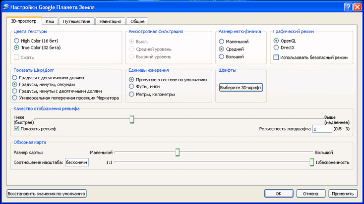
In the “DirectX” graphic mode, there will be a higher quality display of images loaded by the program. You can experiment with the quality of the relief display. I am using the program settings shown in this image on my computer.

If you want the pictures not to be distorted when you zoom in, then go to the “Tools” => “Settings” => “Navigation” menu.
In the “Navigation” tab, uncheck the checkbox next to the item “Tilt automatically and enter viewing from the ground”, and then check the checkbox next to the item “Do not tilt when viewing automatically”. You can check the box “Gradually slow down the rotation of the Earth when turning or approaching.” After that, click on the “OK” button.
In this article I talk only about the main features of the program. You yourself can enter the program menu items and make the appropriate settings for your needs.
You can simply navigate the satellite map of the Earth in manual mode using the program's control buttons, or simply using the mouse.
To look at space images, you will have to wait a little while the image is downloaded completely from the Internet. An image taken from a higher altitude loads faster.
To move to a specific geographical location, you need to enter the name of the locality in the “Search” field. When you enter a name in the “Search” field, hints appear. You can add a street and house number to the city name.
This, however, applies to large populated areas. If the settlement is small and located in a rural area, it is better to enter the name of a nearby city so that you can get to the place you are interested in from there. Not all small settlements can be indicated with text on the images in the program.
The detail of satellite maps depends on the population of a particular area. More densely populated areas of the Earth have more detailed images than sparsely populated areas. Deserts, jungles and polar regions do not have very high detail in the images.
Images of the Earth are gradually updated; in the lower right corner of the program window there is the date of shooting of a specific location.
Traveling in Google Earth
In order to move to a specific place, you need to enter the name of this place in the “Search” field. Enter the expression “Niagara Falls” in the “Search” field, and then double-click on the “Start Search” icon located next to it. The program will take you to the selected location.
In the image that opens, you will see what Niagara Falls looks like from a height of 3.01 km.

You can get close to the waterfall and view it from all sides. In the image you see a view of the waterfall from a height of 604 meters. This image shows many markings of the places where the photographs were taken.
Other objects are also noted on satellite images. These could be hotels, various institutions, attractions, large stores, historical monuments and much more. When you right-click on such an object, the background information about this particular object.

When you click on a photo tag, you will see a photo taken from the marked location in the image. You can also add your photos by uploading them to the Panoramio photo hosting site with the coordinates of the shooting location.

You can see Niagara Falls from the other side by moving to a new location.

You can hide photo marks from being displayed on the uploaded image. To do this, go to the “Side Panel” by clicking on the corresponding button. In the “Side Panel”, in the “Layers” section, you will need to uncheck the box next to the “Photos” item. After this, these marks will not appear on the image.
If you want to remove all unnecessary information from images, then you need to uncheck the checkbox next to the “Main Database” item in the “Layers” section, and then close the “Side Panel”.
In the Layers section, you can add or remove various effects, such as displaying 3D buildings. Such displays of 3D buildings are available mainly for large cities, mainly located in the USA and Western Europe.

In the image, near the famous Eiffel Tower, you see not only cars, but even individual people standing near the tower. Using the program you can also view historical photographs made in this place.

Flight simulator in Google Earth
In Google Earth, you can simulate a flight on a virtual simulator by selecting the type of aircraft. To do this, you need to go to the “Tools” menu, and then click on the “Enter flight simulator” item.
In the Flight Simulator window, you can select the type of aircraft and the starting position to begin the flight. After this, you need to click on the “Start flight” button.

After that, you can fly over the ground in a virtual plane.

View the surface of the Moon and Mars
Using Google Earth you can see the surface of the Moon and Mars. To do this, click on the button with the image of the planet and select the appropriate item. To image the surface of the Moon and Mars, space photographs taken by the American agency NASA are used.
You can change the height of the Sun and therefore change the angle of the shadow. This image shows the surface of Mars.

If you select the “Sky” item, then using the program you can view the night sky and objects of the Universe on a star map. The image is complemented by photographs taken using the Hubble Space Telescope. When you click on an object, additional help information is displayed.
In some places you can go underwater and see the topography of the seabed if you check the appropriate boxes in the “Layers” section.
The program allows you to take tours of attractions. In Google Earth, you can create your own trips and save them for later viewing. To do this, check the appropriate boxes in the “Layers” section.
In the “File” menu, after clicking on the “View on Google Maps” item, you can view the plot of land you have selected using the service of the same name. To go back to Google Earth, click on the “Back to Google Earth” button in the upper left corner.
Satellite photos can be saved to your computer. To do this, after you have chosen a location to save, simultaneously press the “Ctrl” + “Alt” + “S” buttons on your keyboard.
In the Explorer window that opens, select a location to save the image and give the image a name. After that, click on the “Save” button.
The free Google Earth program can be used not only for entertainment, but for practical purposes. For example, you are planning a vacation, or going on a business trip. You can first look at the place you are interested in using Google Earth.
After this, you will already have a certain idea about this place, and you can choose a place to relax more consciously.
Conclusions of the article
Using the Google Earth program, you can look at any place on the globe using satellite photos, and also find in the program the house where you live or the place where you will go on vacation.
A new experiment has been launched on the International Space Station - High Definition Earth Viewing (HDEV). 4 HD cameras were installed on the ISS; the satellite broadcasts the image online in real time. Everyone can feel like an astronaut and look at our planet from space!
HD cameras are sealed in a temperature-controlled housing. While the experiment is in operation, views are typically sequential, albeit from different cameras. Between switching cameras, appears gray, or black background. When the ISS is in shadow, the video may be interrupted, keep an eye on the map to stay informed. Analysis of this experiment will be conducted to evaluate the impact of the space environment on hardware and video quality for future missions.
A dark screen means the International Space Station is on the night side of planet Earth. If you see a gray background in the video, it means that switching between cameras is currently taking place, or communication with the ISS is not available.
Enjoy watching!
Planet Earth from satellite in real time
Earth map online
Below on the map you can see online where the ISS is currently located in the orbit and, accordingly, what the cameras on it are broadcasting.
You will learn a lot of interesting and developing things at the legendary training by Itzhak Pintosevich “™”! Discover the planet of your dreams!
Almost everyone in childhood dreamed of becoming an astronaut in order to visit the place where only a few people were. Space is amazing and beautiful place, which we do not know at all: mysterious, beautiful and, at the same time, terribly dangerous. Many in childhood wanted to go to space to see and feel a lot of new things, gain interesting knowledge and, of course, look at the Earth from space, and much more. In the not so distant past this was impossible, but now everyone can see the Earth from a satellite. Planet Earth from a satellite is very beautiful, it seems so calm that all the problems down there are not that big on the scale of space.
Planet Earth from satellite and surface
Of course, on Earth, even without space, there are a lot of beautiful and interesting places. Many of them were built by nature itself, while others were already created by man. The surface is beautiful and unique, each place is different and this makes it even more beautiful. But none of this compares to the view of the Earth from a satellite. If anyone manages to see this, he will no longer be able to forget such beauty. Satellite images of planet Earth will be given below or you can use the map from Google Maps.
Observing the Earth from satellites is now commonplace. From a satellite you can observe various. Also, with the help of satellites, people can predict weather changes in various parts of the planet, take pictures of certain areas of the surface, and much more. In addition to this, satellites in the orbits of our planet do a lot of important work: they conduct various experiments in weightlessness, observe how certain phenomena that we are accustomed to on the planet behave in weightlessness, conduct research in various physical, mathematical, biological and other fields of science.
We also recommend
 The relationship between man and nature
 Contemporary heroes. Heroes of Russia. Work for courageous people
 Temple of the Tikhvin Icon of the Mother of God on Ave.
 The miraculous icon of St. Nicholas of Zaraisk St. Nicholas of Zaraisk with life
 How to smoke cheek meat at home
 Receiving a property deduction through an employer